|
|
|||||||||||||||||
| Point ID: 5457 | Downloads | Plots | Site Data | Code: 05KH011 |
|
|
|||||||||||||||||
| Download | |
|---|---|
| Site Descriptor Information | Site Time Series Data |
| Link to all available data | |
| View: | Time Series | All |
| Units: | mm |
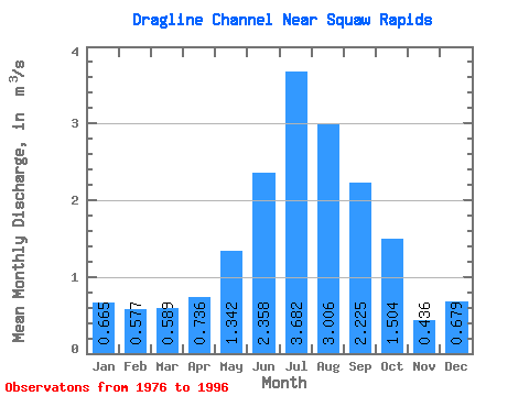
| Statistic | Jan | Feb | Mar | Apr | May | Jun | Jul | Aug | Sep | Oct | Nov | Dec | Annual |
|---|---|---|---|---|---|---|---|---|---|---|---|---|---|
| Mean | 0.67 | 0.58 | 0.59 | 0.74 | 1.34 | 2.36 | 3.68 | 3.01 | 2.23 | 1.50 | 0.44 | 0.68 | 1.49 |
| Standard Deviation | 0.61 | 0.40 | 0.34 | 0.42 | 1.89 | 3.19 | 3.61 | 3.43 | 2.52 | 1.98 | 0.34 | 0.43 | 1.00 |
| Min | 0.04 | 0.03 | 0.05 | 0.06 | 0.12 | 0.04 | 0.00 | 0.00 | 0.00 | 0.00 | 0.00 | 0.00 | 0.13 |
| Max | 2.76 | 1.63 | 1.37 | 1.57 | 6.89 | 12.90 | 11.70 | 11.30 | 7.83 | 6.24 | 1.23 | 1.68 | 3.24 |
| Coefficient of Variation | 0.91 | 0.69 | 0.58 | 0.57 | 1.41 | 1.35 | 0.98 | 1.14 | 1.14 | 1.32 | 0.77 | 0.63 | 0.67 |
 Return to R-Arctic Net Home Page