|
|
|||||||||||||||||
| Point ID: 5455 | Downloads | Plots | Site Data | Code: 05KH009 |
|
|
|||||||||||||||||
| Download | |
|---|---|
| Site Descriptor Information | Site Time Series Data |
| Link to all available data | |
| View: | Time Series | All |
| Units: | mm |
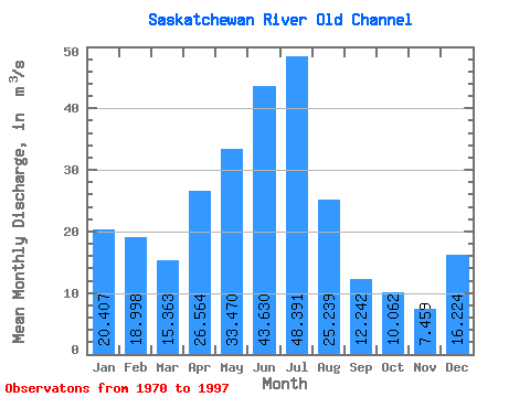
| Statistic | Jan | Feb | Mar | Apr | May | Jun | Jul | Aug | Sep | Oct | Nov | Dec | Annual |
|---|---|---|---|---|---|---|---|---|---|---|---|---|---|
| Mean | 20.41 | 19.00 | 15.36 | 26.56 | 33.47 | 43.63 | 48.39 | 25.24 | 12.24 | 10.06 | 7.46 | 16.22 | 22.50 |
| Standard Deviation | 12.29 | 13.56 | 12.39 | 29.18 | 54.71 | 46.58 | 46.33 | 28.44 | 9.59 | 8.39 | 5.83 | 11.25 | 15.66 |
| Min | 1.34 | 0.92 | 1.64 | 4.91 | 1.80 | 1.25 | 3.45 | 0.20 | 0.55 | 0.23 | 1.09 | 2.64 | 3.48 |
| Max | 49.70 | 47.00 | 51.20 | 140.00 | 262.00 | 164.00 | 185.00 | 123.00 | 35.50 | 28.90 | 23.70 | 48.50 | 71.34 |
| Coefficient of Variation | 0.60 | 0.71 | 0.81 | 1.10 | 1.64 | 1.07 | 0.96 | 1.13 | 0.78 | 0.83 | 0.78 | 0.69 | 0.70 |
 Return to R-Arctic Net Home Page