|
|
|||||||||||||||||
| Point ID: 5454 | Downloads | Plots | Site Data | Other Close Sites | Code: 05KH008 |
|
|
|||||||||||||||||
| Download | |
|---|---|
| Site Descriptor Information | Site Time Series Data |
| Link to all available data | |
| View: | Time Series | All |
| Units: | mm |
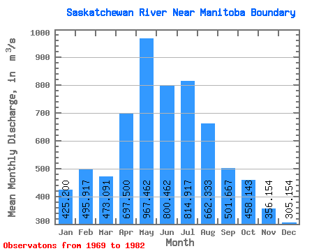
| Statistic | Jan | Feb | Mar | Apr | May | Jun | Jul | Aug | Sep | Oct | Nov | Dec | Annual |
|---|---|---|---|---|---|---|---|---|---|---|---|---|---|
| Mean | 425.20 | 495.92 | 473.09 | 697.50 | 967.46 | 800.46 | 814.92 | 662.33 | 501.67 | 458.14 | 356.15 | 305.15 | 572.15 |
| Standard Deviation | 63.29 | 70.30 | 89.84 | 148.86 | 486.76 | 310.53 | 314.47 | 256.65 | 132.66 | 106.82 | 74.60 | 61.63 | 150.12 |
| Min | 281.00 | 374.00 | 353.00 | 499.00 | 431.00 | 333.00 | 383.00 | 362.00 | 337.00 | 307.00 | 238.00 | 227.00 | 410.92 |
| Max | 494.00 | 634.00 | 614.00 | 946.00 | 2230.00 | 1650.00 | 1280.00 | 1070.00 | 783.00 | 665.00 | 517.00 | 434.00 | 913.75 |
| Coefficient of Variation | 0.15 | 0.14 | 0.19 | 0.21 | 0.50 | 0.39 | 0.39 | 0.39 | 0.26 | 0.23 | 0.21 | 0.20 | 0.26 |
| Other Close Sites | ||||||
|---|---|---|---|---|---|---|
| PointID | Latitude | Longitude | Drainage Area | Source | Name | |
| 5456 | "SASKATCHEWAN RIVER BELOW CUMBERLAND HOUSE" | 53.88 | 816597 | Hydat | ||
 Return to R-Arctic Net Home Page