|
|
|||||||||||||||||
| Point ID: 5443 | Downloads | Plots | Site Data | Code: 05KE001 |
|
|
|||||||||||||||||
| Download | |
|---|---|
| Site Descriptor Information | Site Time Series Data |
| Link to all available data | |
| View: | Time Series | All |
| Units: | mm |
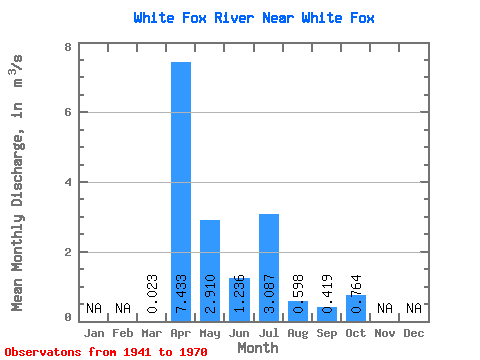
| Statistic | Jan | Feb | Mar | Apr | May | Jun | Jul | Aug | Sep | Oct | Nov | Dec | Annual |
|---|---|---|---|---|---|---|---|---|---|---|---|---|---|
| Mean | 0.02 | 7.43 | 2.91 | 1.24 | 3.09 | 0.60 | 0.42 | 0.76 | |||||
| Standard Deviation | 0.05 | 6.98 | 2.83 | 2.18 | 4.43 | 0.50 | 0.81 | 1.55 | |||||
| Min | 0.00 | 0.04 | 0.05 | 0.04 | 0.00 | 0.00 | 0.00 | 0.00 | |||||
| Max | 0.12 | 19.50 | 8.34 | 6.09 | 10.70 | 1.15 | 1.86 | 3.54 | |||||
| Coefficient of Variation | 2.24 | 0.94 | 0.97 | 1.76 | 1.44 | 0.84 | 1.93 | 2.03 |
 Return to R-Arctic Net Home Page