|
|
|||||||||||||||||
| Point ID: 5439 | Downloads | Plots | Site Data | Code: 05KD001 |
|
|
|||||||||||||||||
| Download | |
|---|---|
| Site Descriptor Information | Site Time Series Data |
| Link to all available data | |
| View: | Time Series | All |
| Units: | mm |
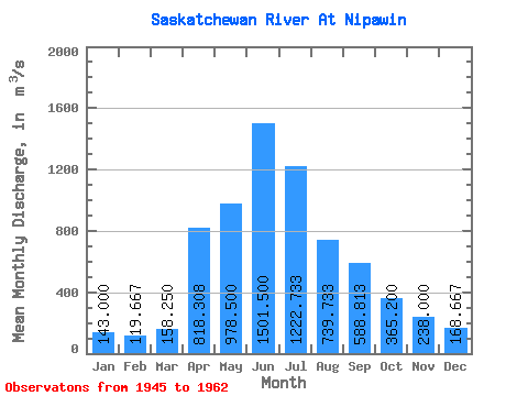
| Statistic | Jan | Feb | Mar | Apr | May | Jun | Jul | Aug | Sep | Oct | Nov | Dec | Annual |
|---|---|---|---|---|---|---|---|---|---|---|---|---|---|
| Mean | 143.00 | 119.67 | 158.25 | 818.31 | 978.50 | 1501.50 | 1222.73 | 739.73 | 588.81 | 365.20 | 238.00 | 168.67 | 528.54 |
| Standard Deviation | 15.72 | 11.68 | 38.30 | 385.45 | 747.52 | 710.45 | 405.41 | 218.12 | 461.80 | 175.90 | 100.37 | 35.70 | 73.95 |
| Min | 129.00 | 107.00 | 115.00 | 406.00 | 329.00 | 755.00 | 562.00 | 420.00 | 286.00 | 206.00 | 143.00 | 131.00 | 476.25 |
| Max | 160.00 | 130.00 | 249.00 | 1850.00 | 3360.00 | 3040.00 | 1900.00 | 1090.00 | 2160.00 | 824.00 | 343.00 | 202.00 | 580.83 |
| Coefficient of Variation | 0.11 | 0.10 | 0.24 | 0.47 | 0.76 | 0.47 | 0.33 | 0.29 | 0.78 | 0.48 | 0.42 | 0.21 | 0.14 |
 Return to R-Arctic Net Home Page