|
|
|||||||||||||||||
| Point ID: 542 | Downloads | Plots | Site Data | Code: 05FB002 |
|
|
|||||||||||||||||
| Download | |
|---|---|
| Site Descriptor Information | Site Time Series Data |
| Link to all available data | |
| View: | Time Series | All |
| Units: | mm |
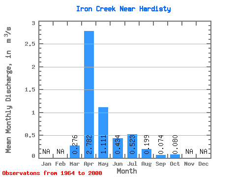
| Statistic | Jan | Feb | Mar | Apr | May | Jun | Jul | Aug | Sep | Oct | Nov | Dec | Annual |
|---|---|---|---|---|---|---|---|---|---|---|---|---|---|
| Mean | 0.28 | 2.78 | 1.11 | 0.43 | 0.52 | 0.20 | 0.07 | 0.08 | |||||
| Standard Deviation | 0.55 | 4.00 | 2.14 | 0.51 | 1.03 | 0.54 | 0.12 | 0.14 | |||||
| Min | 0.00 | 0.25 | 0.01 | 0.00 | 0.00 | 0.00 | 0.00 | 0.00 | |||||
| Max | 2.38 | 23.00 | 12.90 | 2.29 | 5.58 | 3.27 | 0.56 | 0.63 | |||||
| Coefficient of Variation | 2.00 | 1.44 | 1.93 | 1.16 | 1.96 | 2.73 | 1.67 | 1.76 |
 Return to R-Arctic Net Home Page