|
|
|||||||||||||||||
| Point ID: 5417 | Downloads | Plots | Site Data | Code: 05KA001 |
|
|
|||||||||||||||||
| Download | |
|---|---|
| Site Descriptor Information | Site Time Series Data |
| Link to all available data | |
| View: | Time Series | All |
| Units: | mm |
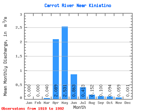
| Statistic | Jan | Feb | Mar | Apr | May | Jun | Jul | Aug | Sep | Oct | Nov | Dec | Annual |
|---|---|---|---|---|---|---|---|---|---|---|---|---|---|
| Mean | 0.00 | 0.00 | 0.04 | 2.09 | 2.53 | 0.86 | 0.41 | 0.15 | 0.10 | 0.09 | 0.06 | 0.00 | 0.41 |
| Standard Deviation | 0.00 | 0.00 | 0.19 | 2.33 | 3.99 | 1.44 | 0.94 | 0.36 | 0.22 | 0.19 | 0.10 | 0.00 | |
| Min | 0.00 | 0.00 | 0.00 | 0.02 | 0.00 | 0.00 | 0.00 | 0.00 | 0.00 | 0.00 | 0.00 | 0.00 | 0.41 |
| Max | 0.00 | 0.00 | 1.33 | 10.70 | 18.10 | 7.54 | 5.97 | 2.21 | 1.08 | 1.02 | 0.18 | 0.00 | 0.41 |
| Coefficient of Variation | 4.80 | 1.12 | 1.58 | 1.67 | 2.28 | 2.36 | 2.16 | 1.97 | 1.73 | 1.73 |
 Return to R-Arctic Net Home Page