|
|
|||||||||||||||||
| Point ID: 5409 | Downloads | Plots | Site Data | Code: 05JM005 |
|
|
|||||||||||||||||
| Download | |
|---|---|
| Site Descriptor Information | Site Time Series Data |
| Link to all available data | |
| View: | Time Series | All |
| Units: | mm |
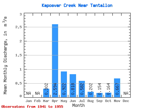
| Statistic | Jan | Feb | Mar | Apr | May | Jun | Jul | Aug | Sep | Oct | Nov | Dec | Annual |
|---|---|---|---|---|---|---|---|---|---|---|---|---|---|
| Mean | 0.30 | 2.59 | 0.92 | 0.82 | 0.58 | 0.20 | 0.15 | 0.16 | 0.67 | ||||
| Standard Deviation | 0.25 | 2.65 | 2.64 | 1.63 | 1.15 | 0.32 | 0.34 | 0.44 | |||||
| Min | 0.07 | 0.14 | 0.00 | 0.00 | 0.00 | 0.00 | 0.00 | 0.00 | 0.67 | ||||
| Max | 0.65 | 10.20 | 10.40 | 6.45 | 4.41 | 0.98 | 1.18 | 1.49 | 0.67 | ||||
| Coefficient of Variation | 0.82 | 1.02 | 2.87 | 1.99 | 1.98 | 1.59 | 2.19 | 2.70 |
 Return to R-Arctic Net Home Page