|
|
|||||||||||||||||
| Point ID: 5403 | Downloads | Plots | Site Data | Code: 05JL001 |
|
|
|||||||||||||||||
| Download | |
|---|---|
| Site Descriptor Information | Site Time Series Data |
| Link to all available data | |
| View: | Time Series | All |
| Units: | mm |
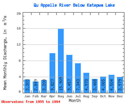
| Statistic | Jan | Feb | Mar | Apr | May | Jun | Jul | Aug | Sep | Oct | Nov | Dec | Annual |
|---|---|---|---|---|---|---|---|---|---|---|---|---|---|
| Mean | 3.30 | 2.85 | 3.21 | 9.83 | 15.91 | 9.46 | 7.34 | 4.97 | 3.47 | 4.07 | 4.50 | 3.98 | 5.69 |
| Standard Deviation | 2.10 | 1.80 | 1.99 | 11.16 | 18.84 | 12.68 | 9.94 | 7.30 | 4.94 | 4.36 | 3.16 | 2.58 | 5.46 |
| Min | 0.57 | 0.57 | 0.00 | 0.47 | 0.56 | 0.17 | 0.31 | 0.06 | 0.01 | 0.00 | 0.10 | 0.14 | 0.62 |
| Max | 9.33 | 7.41 | 7.34 | 49.60 | 65.60 | 42.70 | 35.00 | 26.40 | 23.90 | 20.10 | 14.70 | 12.00 | 21.34 |
| Coefficient of Variation | 0.64 | 0.63 | 0.62 | 1.14 | 1.18 | 1.34 | 1.35 | 1.47 | 1.43 | 1.07 | 0.70 | 0.65 | 0.96 |
 Return to R-Arctic Net Home Page