|
|
|||||||||||||||||
| Point ID: 5395 | Downloads | Plots | Site Data | Code: 05JJ007 |
|
|
|||||||||||||||||
| Download | |
|---|---|
| Site Descriptor Information | Site Time Series Data |
| Link to all available data | |
| View: | Time Series | All |
| Units: | mm |
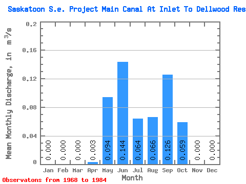
| Statistic | Jan | Feb | Mar | Apr | May | Jun | Jul | Aug | Sep | Oct | Nov | Dec | Annual |
|---|---|---|---|---|---|---|---|---|---|---|---|---|---|
| Mean | 0.00 | 0.00 | 0.00 | 0.00 | 0.09 | 0.14 | 0.06 | 0.07 | 0.13 | 0.06 | 0.00 | 0.00 | 0.00 |
| Standard Deviation | 0.00 | 0.01 | 0.17 | 0.20 | 0.15 | 0.15 | 0.17 | 0.14 | 0.00 | ||||
| Min | 0.00 | 0.00 | 0.00 | 0.00 | 0.00 | 0.00 | 0.00 | 0.00 | 0.00 | 0.00 | 0.00 | 0.00 | 0.00 |
| Max | 0.00 | 0.00 | 0.00 | 0.04 | 0.53 | 0.50 | 0.43 | 0.56 | 0.49 | 0.53 | 0.00 | 0.00 | 0.00 |
| Coefficient of Variation | 3.61 | 1.81 | 1.37 | 2.32 | 2.24 | 1.36 | 2.40 |
 Return to R-Arctic Net Home Page