|
|
|||||||||||||||||
| Point ID: 5390 | Downloads | Plots | Site Data | Code: 05JJ002 |
|
|
|||||||||||||||||
| Download | |
|---|---|
| Site Descriptor Information | Site Time Series Data |
| Link to all available data | |
| View: | Time Series | All |
| Units: | mm |
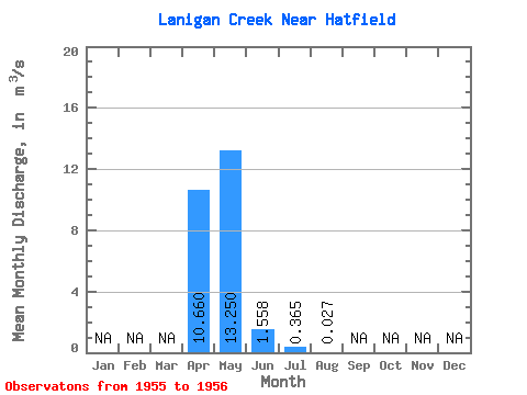
| Statistic | Jan | Feb | Mar | Apr | May | Jun | Jul | Aug | Sep | Oct | Nov | Dec | Annual |
|---|---|---|---|---|---|---|---|---|---|---|---|---|---|
| Mean | 10.66 | 13.25 | 1.56 | 0.36 | 0.03 | ||||||||
| Standard Deviation | 2.46 | 14.64 | 1.01 | ||||||||||
| Min | 8.92 | 2.90 | 0.85 | 0.36 | 0.03 | ||||||||
| Max | 12.40 | 23.60 | 2.27 | 0.36 | 0.03 | ||||||||
| Coefficient of Variation | 0.23 | 1.10 | 0.65 |
 Return to R-Arctic Net Home Page