|
|
|||||||||||||||||
| Point ID: 539 | Downloads | Plots | Site Data | Code: 05FA023 |
|
|
|||||||||||||||||
| Download | |
|---|---|
| Site Descriptor Information | Site Time Series Data |
| Link to all available data | |
| View: | Time Series | All |
| Units: | mm |
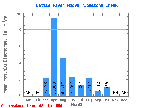
| Statistic | Jan | Feb | Mar | Apr | May | Jun | Jul | Aug | Sep | Oct | Nov | Dec | Annual |
|---|---|---|---|---|---|---|---|---|---|---|---|---|---|
| Mean | 2.19 | 9.38 | 4.62 | 2.27 | 1.39 | 2.22 | 0.71 | 1.10 | |||||
| Standard Deviation | 1.83 | 7.56 | 2.65 | 1.07 | 1.49 | 3.66 | 1.01 | 0.88 | |||||
| Min | 0.78 | 4.66 | 1.57 | 1.04 | 0.43 | 0.10 | 0.05 | 0.28 | |||||
| Max | 4.26 | 18.10 | 6.43 | 3.00 | 3.10 | 6.44 | 1.87 | 2.02 | |||||
| Coefficient of Variation | 0.83 | 0.81 | 0.57 | 0.47 | 1.07 | 1.65 | 1.41 | 0.80 |
 Return to R-Arctic Net Home Page