|
|
|||||||||||||||||
| Point ID: 5387 | Downloads | Plots | Site Data | Code: 05JH001 |
|
|
|||||||||||||||||
| Download | |
|---|---|
| Site Descriptor Information | Site Time Series Data |
| Link to all available data | |
| View: | Time Series | All |
| Units: | mm |
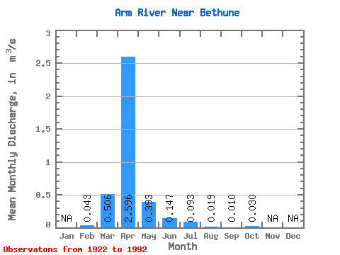
| Statistic | Jan | Feb | Mar | Apr | May | Jun | Jul | Aug | Sep | Oct | Nov | Dec | Annual |
|---|---|---|---|---|---|---|---|---|---|---|---|---|---|
| Mean | 0.04 | 0.51 | 2.60 | 0.39 | 0.15 | 0.09 | 0.02 | 0.01 | 0.03 | ||||
| Standard Deviation | 0.03 | 0.78 | 3.47 | 0.54 | 0.23 | 0.18 | 0.04 | 0.02 | 0.09 | ||||
| Min | 0.02 | 0.00 | 0.01 | 0.00 | 0.00 | 0.00 | 0.00 | 0.00 | 0.00 | ||||
| Max | 0.09 | 3.15 | 14.80 | 2.28 | 1.34 | 0.81 | 0.16 | 0.11 | 0.52 | ||||
| Coefficient of Variation | 0.79 | 1.54 | 1.34 | 1.37 | 1.56 | 1.91 | 2.05 | 2.42 | 2.87 |
 Return to R-Arctic Net Home Page