|
|
|||||||||||||||||
| Point ID: 5384 | Downloads | Plots | Site Data | Code: 05JG013 |
|
|
|||||||||||||||||
| Download | |
|---|---|
| Site Descriptor Information | Site Time Series Data |
| Link to all available data | |
| View: | Time Series | All |
| Units: | mm |
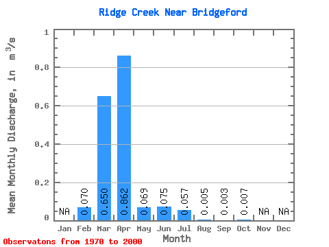
| Statistic | Jan | Feb | Mar | Apr | May | Jun | Jul | Aug | Sep | Oct | Nov | Dec | Annual |
|---|---|---|---|---|---|---|---|---|---|---|---|---|---|
| Mean | 0.07 | 0.65 | 0.86 | 0.07 | 0.07 | 0.06 | 0.01 | 0.00 | 0.01 | ||||
| Standard Deviation | 0.11 | 0.94 | 1.51 | 0.13 | 0.22 | 0.13 | 0.01 | 0.01 | 0.01 | ||||
| Min | 0.00 | 0.00 | 0.01 | 0.01 | 0.00 | 0.00 | 0.00 | 0.00 | 0.00 | ||||
| Max | 0.31 | 3.35 | 6.32 | 0.71 | 1.15 | 0.53 | 0.05 | 0.03 | 0.04 | ||||
| Coefficient of Variation | 1.56 | 1.45 | 1.75 | 1.86 | 2.95 | 2.20 | 2.08 | 1.84 | 1.18 |
 Return to R-Arctic Net Home Page