|
|
|||||||||||||||||
| Point ID: 5381 | Downloads | Plots | Site Data | Code: 05JG010 |
|
|
|||||||||||||||||
| Download | |
|---|---|
| Site Descriptor Information | Site Time Series Data |
| Link to all available data | |
| View: | Time Series | All |
| Units: | mm |
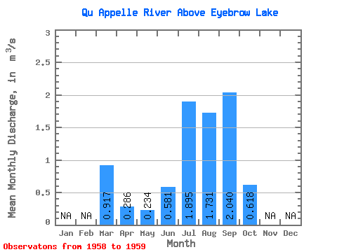
| Statistic | Jan | Feb | Mar | Apr | May | Jun | Jul | Aug | Sep | Oct | Nov | Dec | Annual |
|---|---|---|---|---|---|---|---|---|---|---|---|---|---|
| Mean | 0.92 | 0.29 | 0.23 | 0.58 | 1.90 | 1.73 | 2.04 | 0.62 | |||||
| Standard Deviation | 0.34 | 0.24 | 0.27 | 0.78 | 0.79 | 2.43 | 0.14 | 0.40 | |||||
| Min | 0.67 | 0.12 | 0.04 | 0.03 | 1.34 | 0.01 | 1.94 | 0.34 | |||||
| Max | 1.16 | 0.46 | 0.42 | 1.13 | 2.45 | 3.45 | 2.14 | 0.90 | |||||
| Coefficient of Variation | 0.38 | 0.85 | 1.15 | 1.33 | 0.41 | 1.40 | 0.07 | 0.64 |
 Return to R-Arctic Net Home Page