|
|
|||||||||||||||||
| Point ID: 5379 | Downloads | Plots | Site Data | Code: 05JG006 |
|
|
|||||||||||||||||
| Download | |
|---|---|
| Site Descriptor Information | Site Time Series Data |
| Link to all available data | |
| View: | Time Series | All |
| Units: | mm |
| Statistic | Jan | Feb | Mar | Apr | May | Jun | Jul | Aug | Sep | Oct | Nov | Dec | Annual |
|---|---|---|---|---|---|---|---|---|---|---|---|---|---|
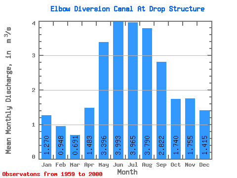
| Mean | 1.27 | 0.95 | 0.69 | 1.48 | 3.40 | 3.99 | 3.96 | 3.79 | 2.82 | 1.74 | 1.75 | 1.42 | 2.27 |
| Standard Deviation | 0.96 | 0.64 | 0.75 | 2.20 | 4.14 | 4.03 | 3.31 | 2.46 | 1.60 | 1.36 | 1.37 | 1.02 | 1.49 |
| Min | 0.00 | 0.00 | 0.00 | 0.00 | 0.01 | 0.01 | 0.00 | 0.00 | 0.00 | 0.00 | 0.00 | 0.00 | 0.00 |
| Max | 4.68 | 1.86 | 2.14 | 9.08 | 13.70 | 14.40 | 14.10 | 9.39 | 6.25 | 5.59 | 7.12 | 5.08 | 6.17 |
| Coefficient of Variation | 0.76 | 0.67 | 1.08 | 1.48 | 1.22 | 1.01 | 0.83 | 0.65 | 0.57 | 0.78 | 0.78 | 0.72 | 0.66 |
 Return to R-Arctic Net Home Page