|
|
|||||||||||||||||
| Point ID: 5366 | Downloads | Plots | Site Data | Code: 05JF004 |
|
|
|||||||||||||||||
| Download | |
|---|---|
| Site Descriptor Information | Site Time Series Data |
| Link to all available data | |
| View: | Time Series | All |
| Units: | mm |
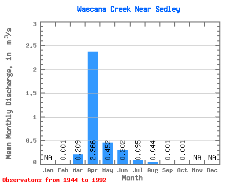
| Statistic | Jan | Feb | Mar | Apr | May | Jun | Jul | Aug | Sep | Oct | Nov | Dec | Annual |
|---|---|---|---|---|---|---|---|---|---|---|---|---|---|
| Mean | 0.00 | 0.21 | 2.37 | 0.45 | 0.30 | 0.10 | 0.04 | 0.00 | 0.00 | ||||
| Standard Deviation | 0.41 | 3.36 | 1.20 | 1.23 | 0.23 | 0.14 | 0.00 | 0.00 | |||||
| Min | 0.00 | 0.00 | 0.00 | 0.00 | 0.00 | 0.00 | 0.00 | 0.00 | 0.00 | ||||
| Max | 0.00 | 1.83 | 13.30 | 7.63 | 8.42 | 1.15 | 0.67 | 0.01 | 0.01 | ||||
| Coefficient of Variation | 1.96 | 1.42 | 2.65 | 4.06 | 2.47 | 3.07 | 2.22 | 3.13 |
 Return to R-Arctic Net Home Page