|
|
|||||||||||||||||
| Point ID: 5362 | Downloads | Plots | Site Data | Code: 05JE008 |
|
|
|||||||||||||||||
| Download | |
|---|---|
| Site Descriptor Information | Site Time Series Data |
| Link to all available data | |
| View: | Time Series | All |
| Units: | mm |
| Statistic | Jan | Feb | Mar | Apr | May | Jun | Jul | Aug | Sep | Oct | Nov | Dec | Annual |
|---|---|---|---|---|---|---|---|---|---|---|---|---|---|
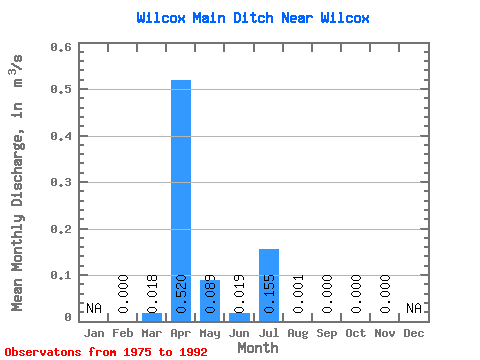
| Mean | 0.00 | 0.02 | 0.52 | 0.09 | 0.02 | 0.15 | 0.00 | 0.00 | 0.00 | 0.00 | |||
| Standard Deviation | 0.04 | 0.99 | 0.16 | 0.07 | 0.51 | 0.00 | 0.00 | 0.00 | |||||
| Min | 0.00 | 0.00 | 0.00 | 0.00 | 0.00 | 0.00 | 0.00 | 0.00 | 0.00 | 0.00 | |||
| Max | 0.00 | 0.15 | 3.49 | 0.54 | 0.30 | 2.12 | 0.01 | 0.00 | 0.01 | 0.00 | |||
| Coefficient of Variation | 1.98 | 1.90 | 1.80 | 3.65 | 3.31 | 2.91 | 3.20 |
 Return to R-Arctic Net Home Page