|
|
|||||||||||||||||
| Point ID: 5360 | Downloads | Plots | Site Data | Code: 05JE005 |
|
|
|||||||||||||||||
| Download | |
|---|---|
| Site Descriptor Information | Site Time Series Data |
| Link to all available data | |
| View: | Time Series | All |
| Units: | mm |
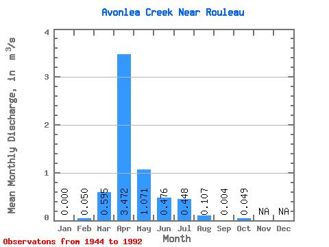
| Statistic | Jan | Feb | Mar | Apr | May | Jun | Jul | Aug | Sep | Oct | Nov | Dec | Annual |
|---|---|---|---|---|---|---|---|---|---|---|---|---|---|
| Mean | 0.00 | 0.05 | 0.59 | 3.47 | 1.07 | 0.48 | 0.45 | 0.11 | 0.00 | 0.05 | |||
| Standard Deviation | 0.06 | 1.35 | 4.58 | 1.85 | 1.77 | 0.96 | 0.28 | 0.01 | 0.11 | ||||
| Min | 0.00 | 0.00 | 0.00 | 0.00 | 0.00 | 0.00 | 0.01 | 0.00 | 0.00 | 0.00 | |||
| Max | 0.00 | 0.17 | 6.32 | 17.30 | 7.89 | 10.40 | 4.52 | 1.40 | 0.02 | 0.41 | |||
| Coefficient of Variation | 1.27 | 2.27 | 1.32 | 1.72 | 3.72 | 2.15 | 2.62 | 1.50 | 2.23 |
 Return to R-Arctic Net Home Page