|
|
|||||||||||||||||
| Point ID: 5349 | Downloads | Plots | Site Data | Code: 05JC001 |
|
|
|||||||||||||||||
| Download | |
|---|---|
| Site Descriptor Information | Site Time Series Data |
| Link to all available data | |
| View: | Time Series | All |
| Units: | mm |
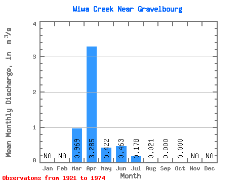
| Statistic | Jan | Feb | Mar | Apr | May | Jun | Jul | Aug | Sep | Oct | Nov | Dec | Annual |
|---|---|---|---|---|---|---|---|---|---|---|---|---|---|
| Mean | 0.97 | 3.29 | 0.42 | 0.46 | 0.18 | 0.02 | 0.00 | 0.00 | |||||
| Standard Deviation | 1.69 | 3.30 | 0.82 | 1.17 | 0.37 | 0.04 | 0.00 | 0.00 | |||||
| Min | 0.00 | 0.00 | 0.00 | 0.00 | 0.00 | 0.00 | 0.00 | 0.00 | |||||
| Max | 5.67 | 10.00 | 2.89 | 4.16 | 1.01 | 0.13 | 0.00 | 0.00 | |||||
| Coefficient of Variation | 1.75 | 1.00 | 1.95 | 2.52 | 2.07 | 2.19 | 3.00 |
 Return to R-Arctic Net Home Page