|
|
|||||||||||||||||
| Point ID: 5333 | Downloads | Plots | Site Data | Code: 05HG019 |
|
|
|||||||||||||||||
| Download | |
|---|---|
| Site Descriptor Information | Site Time Series Data |
| Link to all available data | |
| View: | Time Series | All |
| Units: | mm |
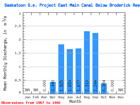
| Statistic | Jan | Feb | Mar | Apr | May | Jun | Jul | Aug | Sep | Oct | Nov | Dec | Annual |
|---|---|---|---|---|---|---|---|---|---|---|---|---|---|
| Mean | 0.00 | 0.44 | 1.82 | 1.65 | 1.68 | 2.31 | 2.24 | 0.38 | 0.00 | ||||
| Standard Deviation | 0.00 | 0.86 | 1.47 | 1.14 | 1.16 | 1.49 | 1.73 | 1.56 | |||||
| Min | 0.00 | 0.00 | 0.00 | 0.01 | 0.04 | 0.01 | 0.00 | 0.00 | 0.00 | ||||
| Max | 0.00 | 2.78 | 4.85 | 3.75 | 3.53 | 6.46 | 7.41 | 7.53 | 0.00 | ||||
| Coefficient of Variation | 1.94 | 0.80 | 0.69 | 0.69 | 0.65 | 0.77 | 4.07 |
 Return to R-Arctic Net Home Page