|
|
|||||||||||||||||
| Point ID: 5328 | Downloads | Plots | Site Data | Code: 05HG010 |
|
|
|||||||||||||||||
| Download | |
|---|---|
| Site Descriptor Information | Site Time Series Data |
| Link to all available data | |
| View: | Time Series | All |
| Units: | mm |
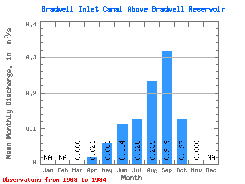
| Statistic | Jan | Feb | Mar | Apr | May | Jun | Jul | Aug | Sep | Oct | Nov | Dec | Annual |
|---|---|---|---|---|---|---|---|---|---|---|---|---|---|
| Mean | 0.00 | 0.02 | 0.06 | 0.11 | 0.13 | 0.23 | 0.32 | 0.13 | 0.00 | ||||
| Standard Deviation | 0.00 | 0.07 | 0.08 | 0.14 | 0.16 | 0.17 | 0.21 | 0.23 | 0.00 | ||||
| Min | 0.00 | 0.00 | 0.00 | 0.00 | 0.00 | 0.00 | 0.00 | 0.00 | 0.00 | ||||
| Max | 0.00 | 0.23 | 0.25 | 0.44 | 0.43 | 0.52 | 0.67 | 0.68 | 0.00 | ||||
| Coefficient of Variation | 3.32 | 1.35 | 1.25 | 1.27 | 0.71 | 0.67 | 1.81 |
 Return to R-Arctic Net Home Page