|
|
|||||||||||||||||
| Point ID: 5324 | Downloads | Plots | Site Data | Code: 05HG005 |
|
|
|||||||||||||||||
| Download | |
|---|---|
| Site Descriptor Information | Site Time Series Data |
| Link to all available data | |
| View: | Time Series | All |
| Units: | mm |
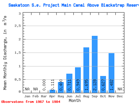
| Statistic | Jan | Feb | Mar | Apr | May | Jun | Jul | Aug | Sep | Oct | Nov | Dec | Annual |
|---|---|---|---|---|---|---|---|---|---|---|---|---|---|
| Mean | 0.00 | 0.11 | 0.40 | 0.71 | 0.95 | 1.69 | 2.13 | 0.63 | 1.48 | ||||
| Standard Deviation | 0.00 | 0.34 | 0.47 | 0.69 | 1.17 | 1.32 | 1.51 | 1.64 | 2.96 | ||||
| Min | 0.00 | 0.00 | 0.00 | 0.00 | 0.00 | 0.00 | 0.01 | 0.00 | 0.00 | ||||
| Max | 0.00 | 1.22 | 1.51 | 1.93 | 4.29 | 6.05 | 6.64 | 6.72 | 5.93 | ||||
| Coefficient of Variation | 3.06 | 1.17 | 0.96 | 1.23 | 0.78 | 0.71 | 2.62 | 2.00 |
 Return to R-Arctic Net Home Page