|
|
|||||||||||||||||
| Point ID: 5311 | Downloads | Plots | Site Data | Code: 05HF007 |
|
|
|||||||||||||||||
| Download | |
|---|---|
| Site Descriptor Information | Site Time Series Data |
| Link to all available data | |
| View: | Time Series | All |
| Units: | mm |
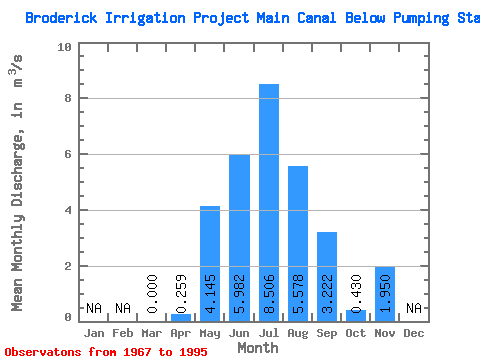
| Statistic | Jan | Feb | Mar | Apr | May | Jun | Jul | Aug | Sep | Oct | Nov | Dec | Annual |
|---|---|---|---|---|---|---|---|---|---|---|---|---|---|
| Mean | 0.00 | 0.26 | 4.14 | 5.98 | 8.51 | 5.58 | 3.22 | 0.43 | 1.95 | ||||
| Standard Deviation | 0.00 | 0.83 | 2.53 | 3.09 | 4.28 | 3.46 | 2.40 | 1.62 | 2.76 | ||||
| Min | 0.00 | 0.00 | 0.15 | 0.99 | 1.98 | 0.35 | 0.03 | 0.00 | 0.00 | ||||
| Max | 0.00 | 3.18 | 9.64 | 13.40 | 16.10 | 13.00 | 7.79 | 8.08 | 3.90 | ||||
| Coefficient of Variation | 3.21 | 0.61 | 0.52 | 0.50 | 0.62 | 0.74 | 3.77 | 1.41 |
 Return to R-Arctic Net Home Page