|
|
|||||||||||||||||
| Point ID: 5305 | Downloads | Plots | Site Data | Code: 05HD041 |
|
|
|||||||||||||||||
| Download | |
|---|---|
| Site Descriptor Information | Site Time Series Data |
| Link to all available data | |
| View: | Time Series | All |
| Units: | mm |
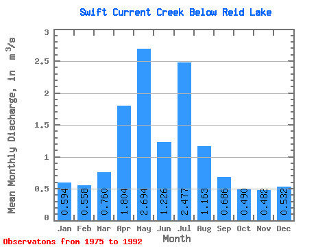
| Statistic | Jan | Feb | Mar | Apr | May | Jun | Jul | Aug | Sep | Oct | Nov | Dec | Annual |
|---|---|---|---|---|---|---|---|---|---|---|---|---|---|
| Mean | 0.59 | 0.56 | 0.76 | 1.80 | 2.69 | 1.23 | 2.48 | 1.16 | 0.69 | 0.49 | 0.48 | 0.53 | 1.11 |
| Standard Deviation | 0.25 | 0.20 | 1.22 | 1.81 | 1.03 | 0.67 | 1.10 | 0.59 | 0.38 | 0.34 | 0.28 | 0.25 | 0.33 |
| Min | 0.19 | 0.21 | 0.15 | 0.02 | 1.09 | 0.35 | 0.45 | 0.45 | 0.27 | 0.07 | 0.11 | 0.20 | 0.58 |
| Max | 1.06 | 0.93 | 5.45 | 6.47 | 4.50 | 2.42 | 4.84 | 2.26 | 1.45 | 1.27 | 1.08 | 0.97 | 1.77 |
| Coefficient of Variation | 0.42 | 0.36 | 1.60 | 1.00 | 0.38 | 0.54 | 0.44 | 0.51 | 0.55 | 0.69 | 0.58 | 0.46 | 0.30 |
 Return to R-Arctic Net Home Page