|
|
|||||||||||||||||
| Point ID: 5300 | Downloads | Plots | Site Data | Code: 05HD034 |
|
|
|||||||||||||||||
| Download | |
|---|---|
| Site Descriptor Information | Site Time Series Data |
| Link to all available data | |
| View: | Time Series | All |
| Units: | mm |
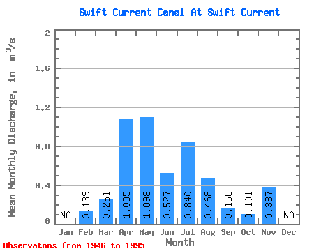
| Statistic | Jan | Feb | Mar | Apr | May | Jun | Jul | Aug | Sep | Oct | Nov | Dec | Annual |
|---|---|---|---|---|---|---|---|---|---|---|---|---|---|
| Mean | 0.14 | 0.25 | 1.08 | 1.10 | 0.53 | 0.84 | 0.47 | 0.16 | 0.10 | 0.39 | |||
| Standard Deviation | 0.12 | 0.41 | 1.25 | 1.14 | 0.37 | 0.70 | 0.40 | 0.32 | 0.23 | 0.55 | |||
| Min | 0.03 | 0.00 | 0.00 | 0.00 | 0.00 | 0.06 | 0.00 | 0.00 | 0.00 | 0.00 | |||
| Max | 0.29 | 1.44 | 3.41 | 3.82 | 1.41 | 2.99 | 1.99 | 1.78 | 1.11 | 0.77 | |||
| Coefficient of Variation | 0.83 | 1.64 | 1.16 | 1.04 | 0.71 | 0.83 | 0.86 | 2.02 | 2.23 | 1.41 |
 Return to R-Arctic Net Home Page