|
|
|||||||||||||||||
| Point ID: 5281 | Downloads | Plots | Site Data | Code: 05HC001 |
|
|
|||||||||||||||||
| Download | |
|---|---|
| Site Descriptor Information | Site Time Series Data |
| Link to all available data | |
| View: | Time Series | All |
| Units: | mm |
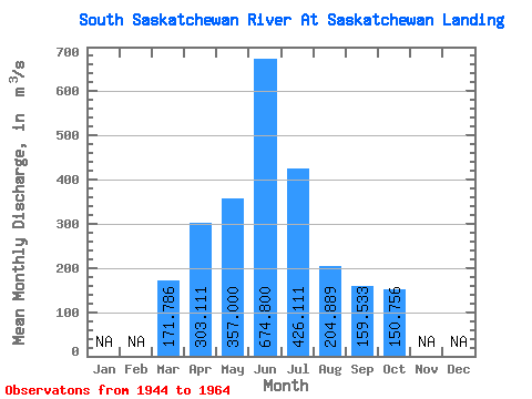
| Statistic | Jan | Feb | Mar | Apr | May | Jun | Jul | Aug | Sep | Oct | Nov | Dec | Annual |
|---|---|---|---|---|---|---|---|---|---|---|---|---|---|
| Mean | 171.79 | 303.11 | 357.00 | 674.80 | 426.11 | 204.89 | 159.53 | 150.76 | |||||
| Standard Deviation | 96.13 | 158.13 | 187.69 | 194.20 | 163.73 | 50.05 | 52.21 | 75.98 | |||||
| Min | 97.50 | 141.00 | 107.00 | 441.00 | 171.00 | 158.00 | 71.40 | 60.80 | |||||
| Max | 381.00 | 577.00 | 742.00 | 989.00 | 701.00 | 287.00 | 234.00 | 322.00 | |||||
| Coefficient of Variation | 0.56 | 0.52 | 0.53 | 0.29 | 0.38 | 0.24 | 0.33 | 0.50 |
 Return to R-Arctic Net Home Page