|
|
|||||||||||||||||
| Point ID: 5276 | Downloads | Plots | Site Data | Code: 05HA073 |
|
|
|||||||||||||||||
| Download | |
|---|---|
| Site Descriptor Information | Site Time Series Data |
| Link to all available data | |
| View: | Time Series | All |
| Units: | mm |
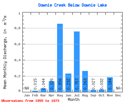
| Statistic | Jan | Feb | Mar | Apr | May | Jun | Jul | Aug | Sep | Oct | Nov | Dec | Annual |
|---|---|---|---|---|---|---|---|---|---|---|---|---|---|
| Mean | 0.01 | 0.04 | 0.14 | 0.86 | 0.23 | 0.76 | 0.26 | 0.03 | 0.03 | 0.18 | |||
| Standard Deviation | 0.03 | 0.16 | 0.66 | 0.26 | 0.38 | 0.28 | 0.06 | 0.09 | |||||
| Min | 0.01 | 0.00 | 0.00 | 0.02 | 0.00 | 0.00 | 0.00 | 0.00 | 0.00 | 0.18 | |||
| Max | 0.01 | 0.13 | 0.45 | 2.88 | 0.90 | 1.37 | 0.94 | 0.22 | 0.37 | 0.18 | |||
| Coefficient of Variation | 0.78 | 1.20 | 0.77 | 1.12 | 0.50 | 1.05 | 2.32 | 2.74 |
 Return to R-Arctic Net Home Page