|
|
|||||||||||||||||
| Point ID: 523 | Downloads | Plots | Site Data | Code: 05EE915 |
|
|
|||||||||||||||||
| Download | |
|---|---|
| Site Descriptor Information | Site Time Series Data |
| Link to all available data | |
| View: | Time Series | All |
| Units: | mm |
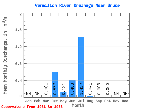
| Statistic | Jan | Feb | Mar | Apr | May | Jun | Jul | Aug | Sep | Oct | Nov | Dec | Annual |
|---|---|---|---|---|---|---|---|---|---|---|---|---|---|
| Mean | 0.00 | 0.60 | 0.12 | 0.40 | 1.43 | 0.04 | 0.00 | 0.00 | |||||
| Standard Deviation | 0.62 | 0.20 | 0.70 | 1.26 | 0.07 | 0.01 | 0.00 | ||||||
| Min | 0.00 | 0.15 | 0.00 | 0.00 | 0.00 | 0.00 | 0.00 | 0.00 | |||||
| Max | 0.00 | 1.31 | 0.35 | 1.21 | 2.40 | 0.12 | 0.01 | 0.00 | |||||
| Coefficient of Variation | 1.04 | 1.66 | 1.73 | 0.89 | 1.61 | 1.73 |
 Return to R-Arctic Net Home Page