|
|
|||||||||||||||||
| Point ID: 5225 | Downloads | Plots | Site Data | Code: 05GG007 |
|
|
|||||||||||||||||
| Download | |
|---|---|
| Site Descriptor Information | Site Time Series Data |
| Link to all available data | |
| View: | Time Series | All |
| Units: | mm |
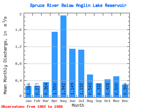
| Statistic | Jan | Feb | Mar | Apr | May | Jun | Jul | Aug | Sep | Oct | Nov | Dec | Annual |
|---|---|---|---|---|---|---|---|---|---|---|---|---|---|
| Mean | 0.27 | 0.28 | 0.36 | 1.55 | 1.94 | 1.15 | 1.13 | 0.54 | 0.33 | 0.43 | 0.50 | 0.30 | 0.86 |
| Standard Deviation | 0.29 | 0.34 | 0.42 | 1.33 | 2.40 | 1.76 | 1.88 | 0.81 | 0.33 | 0.39 | 0.55 | 0.35 | 0.73 |
| Min | 0.00 | 0.00 | 0.00 | 0.05 | 0.14 | 0.12 | 0.06 | 0.10 | 0.11 | 0.10 | 0.00 | 0.00 | 0.15 |
| Max | 1.03 | 1.42 | 1.99 | 5.32 | 9.20 | 7.08 | 6.85 | 3.06 | 1.76 | 1.62 | 2.24 | 1.29 | 3.04 |
| Coefficient of Variation | 1.10 | 1.21 | 1.16 | 0.86 | 1.23 | 1.54 | 1.66 | 1.48 | 1.00 | 0.91 | 1.10 | 1.16 | 0.85 |
 Return to R-Arctic Net Home Page