|
|
|||||||||||||||||
| Point ID: 522 | Downloads | Plots | Site Data | Code: 05EE913 |
|
|
|||||||||||||||||
| Download | |
|---|---|
| Site Descriptor Information | Site Time Series Data |
| Link to all available data | |
| View: | Time Series | All |
| Units: | mm |
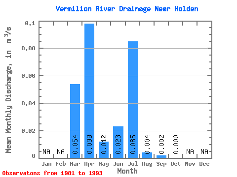
| Statistic | Jan | Feb | Mar | Apr | May | Jun | Jul | Aug | Sep | Oct | Nov | Dec | Annual |
|---|---|---|---|---|---|---|---|---|---|---|---|---|---|
| Mean | 0.05 | 0.10 | 0.01 | 0.02 | 0.09 | 0.00 | 0.00 | 0.00 | |||||
| Standard Deviation | 0.09 | 0.11 | 0.03 | 0.07 | 0.16 | 0.01 | 0.00 | 0.00 | |||||
| Min | 0.00 | 0.00 | 0.00 | 0.00 | 0.00 | 0.00 | 0.00 | 0.00 | |||||
| Max | 0.24 | 0.36 | 0.12 | 0.24 | 0.46 | 0.03 | 0.01 | 0.00 | |||||
| Coefficient of Variation | 1.56 | 1.12 | 2.82 | 2.77 | 1.86 | 2.06 | 1.81 |
 Return to R-Arctic Net Home Page