|
|
|||||||||||||||||
| Point ID: 5213 | Downloads | Plots | Site Data | Code: 05GC005 |
|
|
|||||||||||||||||
| Download | |
|---|---|
| Site Descriptor Information | Site Time Series Data |
| Link to all available data | |
| View: | Time Series | All |
| Units: | mm |
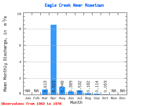
| Statistic | Jan | Feb | Mar | Apr | May | Jun | Jul | Aug | Sep | Oct | Nov | Dec | Annual |
|---|---|---|---|---|---|---|---|---|---|---|---|---|---|
| Mean | 0.61 | 8.52 | 0.95 | 0.39 | 0.53 | 0.18 | 0.11 | 0.06 | |||||
| Standard Deviation | 1.02 | 9.63 | 1.34 | 0.76 | 1.36 | 0.49 | 0.30 | 0.10 | |||||
| Min | 0.00 | 0.12 | 0.01 | 0.01 | 0.00 | 0.00 | 0.00 | 0.00 | |||||
| Max | 2.86 | 22.80 | 3.53 | 2.39 | 4.15 | 1.48 | 0.92 | 0.32 | |||||
| Coefficient of Variation | 1.67 | 1.13 | 1.42 | 1.95 | 2.56 | 2.68 | 2.64 | 1.69 |
 Return to R-Arctic Net Home Page