|
|
|||||||||||||||||
| Point ID: 5210 | Downloads | Plots | Site Data | Code: 05GC002 |
|
|
|||||||||||||||||
| Download | |
|---|---|
| Site Descriptor Information | Site Time Series Data |
| Link to all available data | |
| View: | Time Series | All |
| Units: | mm |
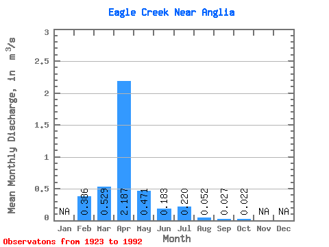
| Statistic | Jan | Feb | Mar | Apr | May | Jun | Jul | Aug | Sep | Oct | Nov | Dec | Annual |
|---|---|---|---|---|---|---|---|---|---|---|---|---|---|
| Mean | 0.39 | 0.53 | 2.19 | 0.47 | 0.18 | 0.22 | 0.05 | 0.03 | 0.02 | ||||
| Standard Deviation | 0.17 | 0.62 | 3.05 | 1.02 | 0.44 | 0.42 | 0.14 | 0.08 | 0.02 | ||||
| Min | 0.26 | 0.00 | 0.07 | 0.01 | 0.00 | 0.00 | 0.00 | 0.00 | 0.00 | ||||
| Max | 0.51 | 2.39 | 9.03 | 4.46 | 1.97 | 1.49 | 0.61 | 0.38 | 0.09 | ||||
| Coefficient of Variation | 0.45 | 1.18 | 1.40 | 2.16 | 2.39 | 1.94 | 2.64 | 2.85 | 0.98 |
 Return to R-Arctic Net Home Page