|
|
|||||||||||||||||
| Point ID: 5206 | Downloads | Plots | Site Data | Code: 05GA001 |
|
|
|||||||||||||||||
| Download | |
|---|---|
| Site Descriptor Information | Site Time Series Data |
| Link to all available data | |
| View: | Time Series | All |
| Units: | mm |
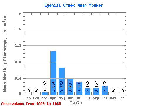
| Statistic | Jan | Feb | Mar | Apr | May | Jun | Jul | Aug | Sep | Oct | Nov | Dec | Annual |
|---|---|---|---|---|---|---|---|---|---|---|---|---|---|
| Mean | 0.06 | 1.06 | 0.65 | 0.41 | 0.30 | 0.16 | 0.16 | 0.22 | |||||
| Standard Deviation | 0.07 | 1.00 | 0.33 | 0.19 | 0.19 | 0.08 | 0.06 | 0.15 | |||||
| Min | 0.00 | 0.12 | 0.26 | 0.16 | 0.09 | 0.07 | 0.09 | 0.11 | |||||
| Max | 0.19 | 3.66 | 1.16 | 0.87 | 0.75 | 0.36 | 0.26 | 0.61 | |||||
| Coefficient of Variation | 1.17 | 0.94 | 0.50 | 0.48 | 0.64 | 0.52 | 0.39 | 0.66 |
 Return to R-Arctic Net Home Page