|
|
|||||||||||||||||
| Point ID: 5190 | Downloads | Plots | Site Data | Code: 05AH001 |
|
|
|||||||||||||||||
| Download | |
|---|---|
| Site Descriptor Information | Site Time Series Data |
| Link to all available data | |
| View: | Time Series | All |
| Units: | mm |
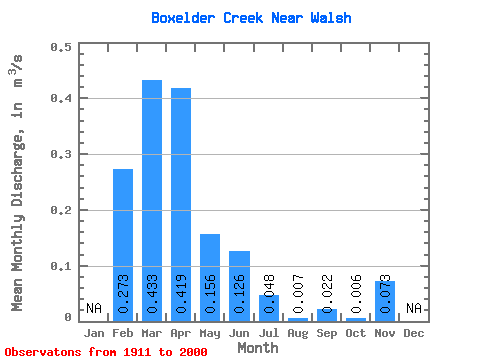
| Statistic | Jan | Feb | Mar | Apr | May | Jun | Jul | Aug | Sep | Oct | Nov | Dec | Annual |
|---|---|---|---|---|---|---|---|---|---|---|---|---|---|
| Mean | 0.27 | 0.43 | 0.42 | 0.16 | 0.13 | 0.05 | 0.01 | 0.02 | 0.01 | 0.07 | |||
| Standard Deviation | 0.52 | 0.58 | 0.92 | 0.37 | 0.34 | 0.17 | 0.04 | 0.11 | 0.02 | 0.10 | |||
| Min | 0.00 | 0.00 | 0.00 | 0.00 | 0.00 | 0.00 | 0.00 | 0.00 | 0.00 | 0.00 | |||
| Max | 1.78 | 2.77 | 4.94 | 2.35 | 1.82 | 1.14 | 0.30 | 0.76 | 0.10 | 0.15 | |||
| Coefficient of Variation | 1.91 | 1.33 | 2.19 | 2.38 | 2.72 | 3.58 | 6.04 | 4.97 | 3.57 | 1.41 |
 Return to R-Arctic Net Home Page