|
|
|||||||||||||||||
| Point ID: 5187 | Downloads | Plots | Site Data | Code: 04NA002 |
|
|
|||||||||||||||||
| Download | |
|---|---|
| Site Descriptor Information | Site Time Series Data |
| Link to all available data | |
| View: | Time Series | All |
| Units: | mm |
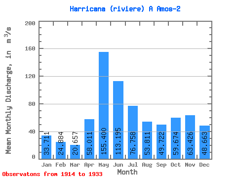
| Statistic | Jan | Feb | Mar | Apr | May | Jun | Jul | Aug | Sep | Oct | Nov | Dec | Annual |
|---|---|---|---|---|---|---|---|---|---|---|---|---|---|
| Mean | 33.71 | 24.88 | 20.66 | 58.01 | 155.40 | 113.19 | 76.76 | 53.81 | 49.72 | 59.67 | 63.43 | 48.66 | 63.37 |
| Standard Deviation | 11.09 | 9.92 | 8.14 | 31.90 | 43.23 | 36.92 | 32.74 | 24.60 | 21.65 | 36.24 | 32.41 | 17.09 | 16.36 |
| Min | 15.40 | 10.70 | 8.98 | 15.00 | 85.60 | 63.70 | 34.60 | 22.80 | 19.50 | 9.40 | 13.00 | 16.80 | 39.63 |
| Max | 51.60 | 48.40 | 46.20 | 125.00 | 258.00 | 191.00 | 135.00 | 94.20 | 107.00 | 155.00 | 151.00 | 77.70 | 108.80 |
| Coefficient of Variation | 0.33 | 0.40 | 0.39 | 0.55 | 0.28 | 0.33 | 0.43 | 0.46 | 0.43 | 0.61 | 0.51 | 0.35 | 0.26 |
 Return to R-Arctic Net Home Page