|
|
|||||||||||||||||
| Point ID: 5179 | Downloads | Plots | Site Data | Code: 03LF002 |
|
|
|||||||||||||||||
| Download | |
|---|---|
| Site Descriptor Information | Site Time Series Data |
| Link to all available data | |
| View: | Time Series | All |
| Units: | mm |
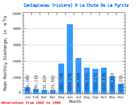
| Statistic | Jan | Feb | Mar | Apr | May | Jun | Jul | Aug | Sep | Oct | Nov | Dec | Annual |
|---|---|---|---|---|---|---|---|---|---|---|---|---|---|
| Mean | 396.09 | 290.12 | 232.62 | 223.58 | 1862.77 | 4268.23 | 2194.56 | 1596.97 | 1533.17 | 1600.68 | 1089.56 | 615.24 | 1335.96 |
| Standard Deviation | 190.56 | 140.20 | 113.83 | 110.15 | 1192.27 | 1951.99 | 999.10 | 914.98 | 625.10 | 516.60 | 497.78 | 296.19 | 450.44 |
| Min | 176.00 | 120.00 | 92.70 | 73.40 | 286.00 | 1030.00 | 641.00 | 408.00 | 460.00 | 655.00 | 415.00 | 252.00 | 606.95 |
| Max | 725.00 | 565.00 | 476.00 | 509.00 | 5860.00 | 8120.00 | 4790.00 | 4270.00 | 3340.00 | 2630.00 | 1990.00 | 1320.00 | 2134.33 |
| Coefficient of Variation | 0.48 | 0.48 | 0.49 | 0.49 | 0.64 | 0.46 | 0.46 | 0.57 | 0.41 | 0.32 | 0.46 | 0.48 | 0.34 |
 Return to R-Arctic Net Home Page