|
|
|||||||||||||||||
| Point ID: 5177 | Downloads | Plots | Site Data | Code: 03LD006 |
|
|
|||||||||||||||||
| Download | |
|---|---|
| Site Descriptor Information | Site Time Series Data |
| Link to all available data | |
| View: | Time Series | All |
| Units: | mm |
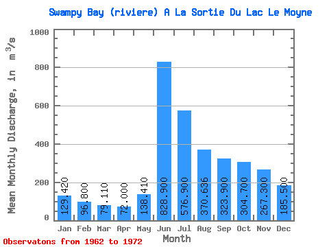
| Statistic | Jan | Feb | Mar | Apr | May | Jun | Jul | Aug | Sep | Oct | Nov | Dec | Annual |
|---|---|---|---|---|---|---|---|---|---|---|---|---|---|
| Mean | 129.42 | 96.80 | 79.11 | 72.00 | 138.41 | 828.90 | 576.90 | 370.64 | 323.90 | 304.70 | 267.30 | 185.50 | 291.73 |
| Standard Deviation | 21.66 | 11.12 | 8.83 | 9.19 | 62.06 | 211.19 | 179.52 | 102.36 | 89.79 | 61.70 | 76.30 | 42.95 | 31.59 |
| Min | 90.20 | 77.10 | 66.40 | 57.80 | 55.80 | 406.00 | 278.00 | 178.00 | 165.00 | 220.00 | 172.00 | 118.00 | 225.55 |
| Max | 161.00 | 113.00 | 89.80 | 85.80 | 267.00 | 1140.00 | 845.00 | 493.00 | 493.00 | 364.00 | 379.00 | 251.00 | 329.77 |
| Coefficient of Variation | 0.17 | 0.12 | 0.11 | 0.13 | 0.45 | 0.26 | 0.31 | 0.28 | 0.28 | 0.20 | 0.28 | 0.23 | 0.11 |
 Return to R-Arctic Net Home Page