|
|
|||||||||||||||||
| Point ID: 5175 | Downloads | Plots | Site Data | Other Close Sites | Code: 03LA002 |
|
|
|||||||||||||||||
| Download | |
|---|---|
| Site Descriptor Information | Site Time Series Data |
| Link to all available data | |
| View: | Time Series | All |
| Units: | mm |
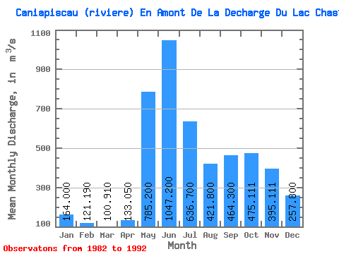
| Statistic | Jan | Feb | Mar | Apr | May | Jun | Jul | Aug | Sep | Oct | Nov | Dec | Annual |
|---|---|---|---|---|---|---|---|---|---|---|---|---|---|
| Mean | 164.00 | 121.19 | 100.91 | 133.05 | 785.20 | 1047.20 | 636.70 | 421.80 | 464.30 | 475.11 | 395.11 | 257.80 | 405.89 |
| Standard Deviation | 23.22 | 14.25 | 12.29 | 73.44 | 368.67 | 327.16 | 270.17 | 175.48 | 173.39 | 112.64 | 99.49 | 56.09 | 88.80 |
| Min | 131.00 | 97.90 | 82.90 | 81.70 | 286.00 | 751.00 | 311.00 | 213.00 | 198.00 | 303.00 | 306.00 | 200.00 | 295.25 |
| Max | 205.00 | 137.00 | 118.00 | 307.00 | 1440.00 | 1840.00 | 1170.00 | 824.00 | 752.00 | 692.00 | 634.00 | 354.00 | 522.75 |
| Coefficient of Variation | 0.14 | 0.12 | 0.12 | 0.55 | 0.47 | 0.31 | 0.42 | 0.42 | 0.37 | 0.24 | 0.25 | 0.22 | 0.22 |
| Other Close Sites | ||||||
|---|---|---|---|---|---|---|
| PointID | Latitude | Longitude | Drainage Area | Source | Name | |
| 5174 | "CANIAPISCAU (RIVIERE) A LA SORTIE DU LAC NOUVEAU" | 53.85 | -1427751 | Hydat | ||
 Return to R-Arctic Net Home Page