|
|
|||||||||||||||||
| Point ID: 517 | Downloads | Plots | Site Data | Code: 05EE004 |
|
|
|||||||||||||||||
| Download | |
|---|---|
| Site Descriptor Information | Site Time Series Data |
| Link to all available data | |
| View: | Time Series | All |
| Units: | mm |
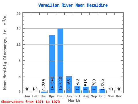
| Statistic | Jan | Feb | Mar | Apr | May | Jun | Jul | Aug | Sep | Oct | Nov | Dec | Annual |
|---|---|---|---|---|---|---|---|---|---|---|---|---|---|
| Mean | 0.29 | 14.35 | 16.01 | 4.17 | 1.76 | 1.52 | 1.78 | 1.01 | |||||
| Standard Deviation | 0.20 | 16.47 | 20.36 | 5.38 | 1.61 | 2.45 | 4.07 | 1.65 | |||||
| Min | 0.11 | 1.22 | 1.20 | 0.73 | 0.11 | 0.12 | 0.11 | 0.17 | |||||
| Max | 0.78 | 54.90 | 65.70 | 17.00 | 4.29 | 7.43 | 11.00 | 4.68 | |||||
| Coefficient of Variation | 0.69 | 1.15 | 1.27 | 1.29 | 0.91 | 1.62 | 2.28 | 1.64 |
 Return to R-Arctic Net Home Page