|
|
|||||||||||||||||
| Point ID: 516 | Downloads | Plots | Site Data | Code: 05EE003 |
|
|
|||||||||||||||||
| Download | |
|---|---|
| Site Descriptor Information | Site Time Series Data |
| Link to all available data | |
| View: | Time Series | All |
| Units: | mm |
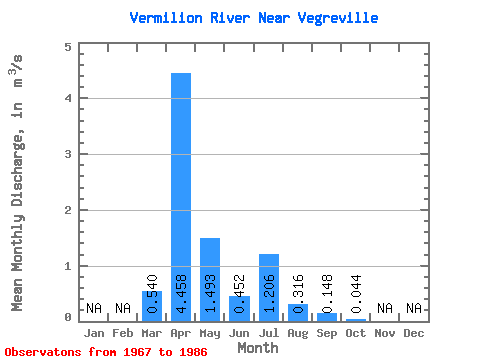
| Statistic | Jan | Feb | Mar | Apr | May | Jun | Jul | Aug | Sep | Oct | Nov | Dec | Annual |
|---|---|---|---|---|---|---|---|---|---|---|---|---|---|
| Mean | 0.54 | 4.46 | 1.49 | 0.45 | 1.21 | 0.32 | 0.15 | 0.04 | |||||
| Standard Deviation | 1.01 | 6.06 | 3.88 | 1.01 | 2.97 | 1.17 | 0.39 | 0.11 | |||||
| Min | 0.00 | 0.05 | 0.00 | 0.00 | 0.00 | 0.00 | 0.00 | 0.00 | |||||
| Max | 3.93 | 25.90 | 16.80 | 3.94 | 10.90 | 5.25 | 1.55 | 0.44 | |||||
| Coefficient of Variation | 1.87 | 1.36 | 2.60 | 2.24 | 2.46 | 3.70 | 2.65 | 2.45 |
 Return to R-Arctic Net Home Page