|
|
|||||||||||||||||
| Point ID: 5149 | Downloads | Plots | Site Data | Code: 03FC001 |
|
|
|||||||||||||||||
| Download | |
|---|---|
| Site Descriptor Information | Site Time Series Data |
| Link to all available data | |
| View: | Time Series | All |
| Units: | mm |
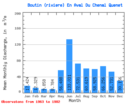
| Statistic | Jan | Feb | Mar | Apr | May | Jun | Jul | Aug | Sep | Oct | Nov | Dec | Annual |
|---|---|---|---|---|---|---|---|---|---|---|---|---|---|
| Mean | 17.42 | 12.33 | 9.86 | 8.78 | 56.49 | 133.03 | 72.53 | 60.62 | 58.92 | 66.26 | 52.73 | 30.16 | 47.85 |
| Standard Deviation | 3.53 | 2.23 | 2.11 | 1.58 | 26.02 | 48.81 | 28.75 | 29.49 | 22.95 | 23.40 | 15.34 | 6.83 | 7.24 |
| Min | 10.70 | 8.19 | 5.81 | 6.00 | 19.50 | 48.00 | 32.40 | 22.80 | 24.70 | 32.70 | 29.50 | 18.80 | 37.25 |
| Max | 22.60 | 17.00 | 14.70 | 11.60 | 103.00 | 227.00 | 150.00 | 134.00 | 96.30 | 118.00 | 88.70 | 41.70 | 62.58 |
| Coefficient of Variation | 0.20 | 0.18 | 0.21 | 0.18 | 0.46 | 0.37 | 0.40 | 0.49 | 0.39 | 0.35 | 0.29 | 0.23 | 0.15 |
 Return to R-Arctic Net Home Page