|
|
|||||||||||||||||
| Point ID: 514 | Downloads | Plots | Site Data | Code: 05EE001 |
|
|
|||||||||||||||||
| Download | |
|---|---|
| Site Descriptor Information | Site Time Series Data |
| Link to all available data | |
| View: | Time Series | All |
| Units: | mm |
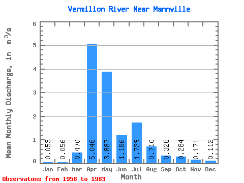
| Statistic | Jan | Feb | Mar | Apr | May | Jun | Jul | Aug | Sep | Oct | Nov | Dec | Annual |
|---|---|---|---|---|---|---|---|---|---|---|---|---|---|
| Mean | 0.05 | 0.06 | 0.47 | 5.05 | 3.89 | 1.19 | 1.73 | 0.71 | 0.33 | 0.28 | 0.17 | 0.11 | 1.31 |
| Standard Deviation | 0.04 | 0.07 | 1.01 | 5.17 | 4.44 | 1.40 | 3.60 | 1.20 | 0.58 | 0.44 | 0.21 | 0.11 | 1.19 |
| Min | 0.00 | 0.00 | 0.00 | 0.46 | 0.49 | 0.20 | 0.03 | 0.00 | 0.00 | 0.00 | 0.00 | 0.00 | 0.19 |
| Max | 0.13 | 0.28 | 4.07 | 22.50 | 15.20 | 5.30 | 15.60 | 4.28 | 2.02 | 1.60 | 0.66 | 0.41 | 3.81 |
| Coefficient of Variation | 0.78 | 1.34 | 2.15 | 1.02 | 1.14 | 1.18 | 2.08 | 1.68 | 1.77 | 1.54 | 1.22 | 0.99 | 0.91 |
 Return to R-Arctic Net Home Page