|
|
|||||||||||||||||
| Point ID: 5113 | Downloads | Plots | Site Data | Other Close Sites | Code: 03DB002 |
|
|
|||||||||||||||||
| Download | |
|---|---|
| Site Descriptor Information | Site Time Series Data |
| Link to all available data | |
| View: | Time Series | All |
| Units: | mm |
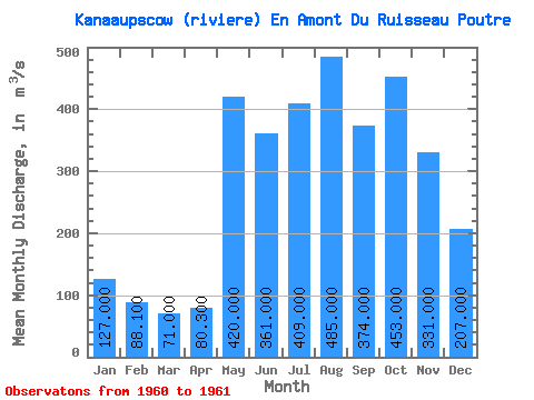
| Statistic | Jan | Feb | Mar | Apr | May | Jun | Jul | Aug | Sep | Oct | Nov | Dec | Annual |
|---|---|---|---|---|---|---|---|---|---|---|---|---|---|
| Mean | 127.00 | 88.10 | 71.00 | 80.30 | 420.00 | 361.00 | 409.00 | 485.00 | 374.00 | 453.00 | 331.00 | 207.00 | |
| Standard Deviation | 103.24 | ||||||||||||
| Min | 127.00 | 88.10 | 71.00 | 80.30 | 420.00 | 288.00 | 409.00 | 485.00 | 374.00 | 453.00 | 331.00 | 207.00 | |
| Max | 127.00 | 88.10 | 71.00 | 80.30 | 420.00 | 434.00 | 409.00 | 485.00 | 374.00 | 453.00 | 331.00 | 207.00 | |
| Coefficient of Variation | 0.29 |
| Other Close Sites | ||||||
|---|---|---|---|---|---|---|
| PointID | Latitude | Longitude | Drainage Area | Source | Name | |
| 5114 | "KANAAUPSCOW (RIVIERE) EN AMONT DU RUISSEAU POUTRE-2" | 53.75 | -893743 | Hydat | ||
| 5116 | "GRANDE RIVIERE (LA) EN AVAL DE LA RIVIERE SAKAMI" | 53.68 | -907562 | Hydat | ||
| 5126 | "SAKAMI (RIVIERE) PRES DE LA GRANDE RIVIERE" | 53.65 | -918413 | Hydat | ||
 Return to R-Arctic Net Home Page