|
|
|||||||||||||||||
| Point ID: 5112 | Downloads | Plots | Site Data | Code: 03DB001 |
|
|
|||||||||||||||||
| Download | |
|---|---|
| Site Descriptor Information | Site Time Series Data |
| Link to all available data | |
| View: | Time Series | All |
| Units: | mm |
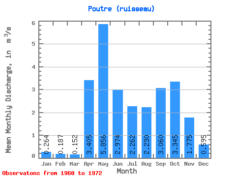
| Statistic | Jan | Feb | Mar | Apr | May | Jun | Jul | Aug | Sep | Oct | Nov | Dec | Annual |
|---|---|---|---|---|---|---|---|---|---|---|---|---|---|
| Mean | 0.26 | 0.19 | 0.15 | 3.41 | 5.86 | 2.97 | 2.26 | 2.23 | 3.06 | 3.34 | 1.77 | 0.59 | 2.18 |
| Standard Deviation | 0.04 | 0.02 | 0.01 | 1.10 | 2.83 | 2.06 | 1.86 | 1.89 | 1.39 | 2.14 | 0.83 | 0.03 | 0.86 |
| Min | 0.24 | 0.17 | 0.14 | 2.63 | 3.36 | 1.78 | 0.73 | 0.49 | 1.35 | 1.19 | 1.19 | 0.57 | 1.56 |
| Max | 0.29 | 0.20 | 0.16 | 4.18 | 10.30 | 6.61 | 6.24 | 5.96 | 4.98 | 5.79 | 2.36 | 0.62 | 2.79 |
| Coefficient of Variation | 0.13 | 0.11 | 0.08 | 0.32 | 0.48 | 0.69 | 0.82 | 0.85 | 0.45 | 0.64 | 0.47 | 0.05 | 0.40 |
 Return to R-Arctic Net Home Page