|
|
|||||||||||||||||
| Point ID: 5110 | Downloads | Plots | Site Data | Code: 03CE001 |
|
|
|||||||||||||||||
| Download | |
|---|---|
| Site Descriptor Information | Site Time Series Data |
| Link to all available data | |
| View: | Time Series | All |
| Units: | mm |
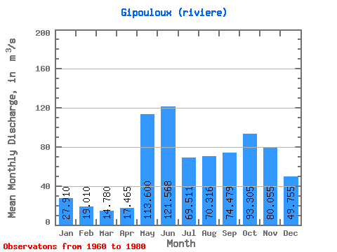
| Statistic | Jan | Feb | Mar | Apr | May | Jun | Jul | Aug | Sep | Oct | Nov | Dec | Annual |
|---|---|---|---|---|---|---|---|---|---|---|---|---|---|
| Mean | 27.91 | 19.01 | 14.78 | 17.46 | 113.60 | 121.57 | 69.51 | 70.32 | 74.48 | 93.31 | 80.06 | 49.76 | 63.22 |
| Standard Deviation | 6.08 | 3.22 | 1.65 | 6.92 | 44.69 | 42.36 | 26.58 | 41.13 | 33.27 | 38.65 | 27.00 | 12.95 | 13.27 |
| Min | 19.40 | 14.70 | 11.90 | 11.70 | 55.30 | 67.70 | 37.80 | 27.00 | 30.40 | 32.40 | 32.20 | 27.80 | 38.34 |
| Max | 40.10 | 25.30 | 18.80 | 39.40 | 212.00 | 239.00 | 160.00 | 200.00 | 132.00 | 183.00 | 136.00 | 75.60 | 87.32 |
| Coefficient of Variation | 0.22 | 0.17 | 0.11 | 0.40 | 0.39 | 0.35 | 0.38 | 0.58 | 0.45 | 0.41 | 0.34 | 0.26 | 0.21 |
 Return to R-Arctic Net Home Page