|
|
|||||||||||||||||
| Point ID: 5108 | Downloads | Plots | Site Data | Code: 03CD001 |
|
|
|||||||||||||||||
| Download | |
|---|---|
| Site Descriptor Information | Site Time Series Data |
| Link to all available data | |
| View: | Time Series | All |
| Units: | mm |
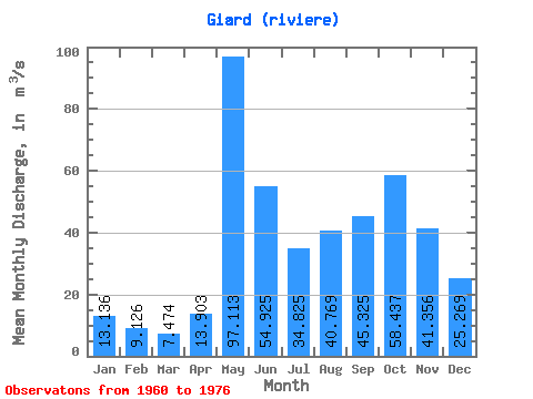
| Statistic | Jan | Feb | Mar | Apr | May | Jun | Jul | Aug | Sep | Oct | Nov | Dec | Annual |
|---|---|---|---|---|---|---|---|---|---|---|---|---|---|
| Mean | 13.14 | 9.13 | 7.47 | 13.90 | 97.11 | 54.92 | 34.83 | 40.77 | 45.33 | 58.44 | 41.36 | 25.27 | 36.97 |
| Standard Deviation | 2.73 | 1.61 | 1.50 | 16.26 | 31.33 | 24.59 | 15.94 | 20.01 | 20.41 | 26.12 | 14.06 | 7.15 | 6.68 |
| Min | 9.17 | 6.80 | 4.23 | 3.68 | 42.00 | 25.60 | 17.90 | 13.90 | 15.80 | 19.70 | 15.40 | 15.60 | 26.36 |
| Max | 19.50 | 12.30 | 9.05 | 70.80 | 178.00 | 102.00 | 78.60 | 79.50 | 82.60 | 99.10 | 63.30 | 41.10 | 47.28 |
| Coefficient of Variation | 0.21 | 0.18 | 0.20 | 1.17 | 0.32 | 0.45 | 0.46 | 0.49 | 0.45 | 0.45 | 0.34 | 0.28 | 0.18 |
 Return to R-Arctic Net Home Page