|
|
|||||||||||||||||
| Point ID: 5101 | Downloads | Plots | Site Data | Code: 03CA001 |
|
|
|||||||||||||||||
| Download | |
|---|---|
| Site Descriptor Information | Site Time Series Data |
| Link to all available data | |
| View: | Time Series | All |
| Units: | mm |
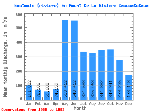
| Statistic | Jan | Feb | Mar | Apr | May | Jun | Jul | Aug | Sep | Oct | Nov | Dec | Annual |
|---|---|---|---|---|---|---|---|---|---|---|---|---|---|
| Mean | 101.08 | 72.11 | 59.69 | 74.16 | 553.41 | 548.41 | 334.69 | 326.06 | 344.88 | 349.94 | 279.24 | 173.12 | 265.24 |
| Standard Deviation | 20.25 | 17.16 | 18.99 | 39.63 | 167.92 | 166.18 | 131.58 | 145.94 | 121.15 | 110.71 | 75.84 | 35.61 | 31.64 |
| Min | 65.90 | 47.20 | 36.50 | 38.80 | 256.00 | 274.00 | 158.00 | 153.00 | 179.00 | 196.00 | 166.00 | 110.00 | 211.23 |
| Max | 145.00 | 107.00 | 111.00 | 203.00 | 819.00 | 946.00 | 647.00 | 629.00 | 644.00 | 628.00 | 420.00 | 229.00 | 311.77 |
| Coefficient of Variation | 0.20 | 0.24 | 0.32 | 0.53 | 0.30 | 0.30 | 0.39 | 0.45 | 0.35 | 0.32 | 0.27 | 0.21 | 0.12 |
 Return to R-Arctic Net Home Page