|
|
|||||||||||||||||
| Point ID: 505 | Downloads | Plots | Site Data | Code: 05EC002 |
|
|
|||||||||||||||||
| Download | |
|---|---|
| Site Descriptor Information | Site Time Series Data |
| Link to all available data | |
| View: | Time Series | All |
| Units: | mm |
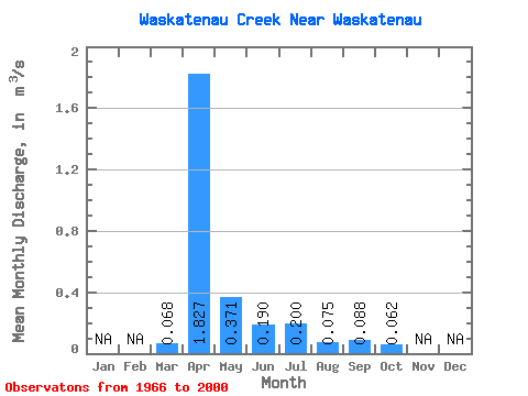
| Statistic | Jan | Feb | Mar | Apr | May | Jun | Jul | Aug | Sep | Oct | Nov | Dec | Annual |
|---|---|---|---|---|---|---|---|---|---|---|---|---|---|
| Mean | 0.07 | 1.83 | 0.37 | 0.19 | 0.20 | 0.07 | 0.09 | 0.06 | |||||
| Standard Deviation | 0.18 | 2.48 | 0.66 | 0.54 | 0.70 | 0.14 | 0.21 | 0.16 | |||||
| Min | 0.00 | 0.00 | 0.00 | 0.00 | 0.00 | 0.00 | 0.00 | 0.00 | |||||
| Max | 0.78 | 8.38 | 2.48 | 2.92 | 4.07 | 0.64 | 0.91 | 0.71 | |||||
| Coefficient of Variation | 2.61 | 1.35 | 1.78 | 2.86 | 3.49 | 1.82 | 2.40 | 2.55 |
 Return to R-Arctic Net Home Page