|
|
|||||||||||||||||
| Point ID: 489 | Downloads | Plots | Site Data | Code: 05EA001 |
|
|
|||||||||||||||||
| Download | |
|---|---|
| Site Descriptor Information | Site Time Series Data |
| Link to all available data | |
| View: | Time Series | All |
| Units: | mm |
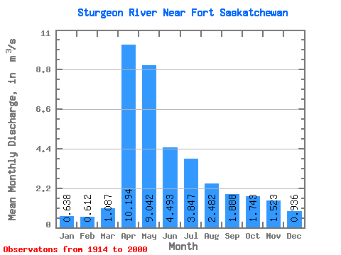
| Statistic | Jan | Feb | Mar | Apr | May | Jun | Jul | Aug | Sep | Oct | Nov | Dec | Annual |
|---|---|---|---|---|---|---|---|---|---|---|---|---|---|
| Mean | 0.64 | 0.61 | 1.09 | 10.19 | 9.04 | 4.49 | 3.85 | 2.48 | 1.89 | 1.74 | 1.52 | 0.94 | 3.21 |
| Standard Deviation | 0.53 | 0.52 | 1.48 | 7.81 | 11.35 | 6.35 | 6.81 | 4.15 | 2.47 | 1.81 | 1.32 | 0.81 | 2.54 |
| Min | 0.00 | 0.00 | 0.00 | 0.99 | 0.41 | 0.06 | 0.02 | 0.03 | 0.04 | 0.02 | 0.16 | 0.02 | 0.53 |
| Max | 1.67 | 1.64 | 7.38 | 39.10 | 60.50 | 31.20 | 32.00 | 24.70 | 12.70 | 8.12 | 4.25 | 2.48 | 7.25 |
| Coefficient of Variation | 0.84 | 0.84 | 1.36 | 0.77 | 1.25 | 1.41 | 1.77 | 1.67 | 1.31 | 1.04 | 0.87 | 0.87 | 0.79 |
 Return to R-Arctic Net Home Page